SDG15.3.1 indicator Land Degradation
Spatial extent: Switzerland, Europe, World
Dashboard link: https://geoessential.unepgrid.ch/mapstore/#/dashboard/36
Temporal extent: 2001-2015
EVs used: Land cover, NDVI, Precipitation, Temperature, Soil Moisture
Inputs: Land cover, NDVI, Precipitation, Temperature, Soil Moisture, Evapotranspiration
Outputs: Land Cover, Land Productivity, Carbon Stocks , Land degradation
Targeted Policy: UN SDG
Targeted Indicator: 15.3.1: Proportion of land that is degraded over total land area
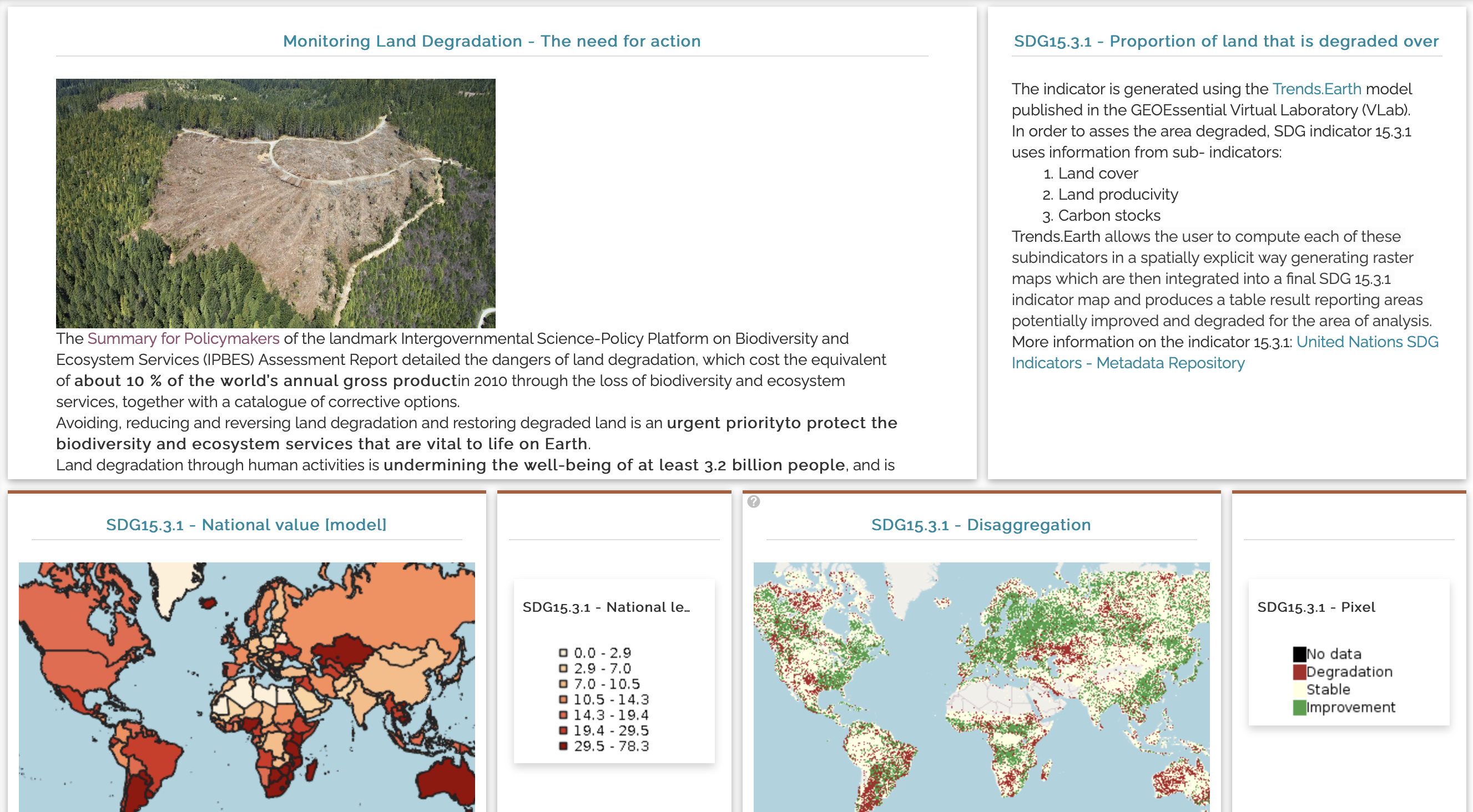
Main process: Trends.Earth model : http://trends.earth Land degradation is defined as “the reduction or loss of the biological or economic productivity and complexity of rain fed cropland, irrigated cropland, or range, pasture, forest and woodlands resulting from a combination of pressures, including land use and management practices”. Total land area is the total surface area of a country less the area covered by inland waters, like major rivers and lakes. The indicator is expressed as a percent. The indicator is derived from a binary classification of land condition (i.e., degraded or not degraded) based on three sub-indicators (and associated metrics): • Land Cover (land cover change) • Land Productivity (land productivity dynamics) • Carbon Stocks (soil organic carbon stocks) Quantifying the indicator is based on the evaluation of changes in the sub-indicators in order to determine the extent of land that is degraded over total land area. The sub-indicators are few in number, complementary and non-additive components of land-based natural capital and sensitive to different degradation factors. The One Out, All Out (1OAO) principle is applied: if one of the sub-indicators is negative (or stable when degraded in the baseline or previous monitoring year) for a particular land unit, then that land unit would be considered as degraded subject to validation by national authorities. This rule is applied as a precautionary measure, because stability or improvements in land condition in any of the three indicators cannot compensate for degradation in the others.
Level of development: 100%
GitHub code: https://github.com/GRIDgva/SwissDataCube/tree/master/notebooks/land_degradation
Outputs endpoints: https://geoessential.unepgrid.ch/geoserver/ and https://geoessential.unepgrid.ch/geonetwork
Link to the VLab: https://vlab.geodab.org
Partner(s): UNIGE, CNR, JRC, ESA
Contact Person: Gregory Giuliani - University of Geneva
Additional information: This workflow is also featured in the GEOSS platform > search for Land Degradation
Data Story
Videos
Poster
Publications
Giuliani G., Chatenoux B., Benvenuti A., Lacroix P., Santoro M., Mazzetti P. (2020) Monitoring Land Degradation at national level using satellite Earth Observation time-series data to support SDG15 - Exploring the potential of Data Cube, Big Earth Data, 4:1, 3-22, DOI: 10.1080/20964471.2020.1711633